Home » Mexico Destinations » San Carlos » San Carlos Driving
San Carlos Driving Directions
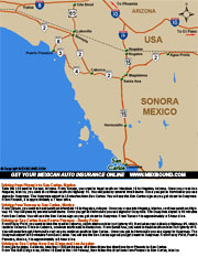
Welcome to the mexbound.com guide to driving to San Carlos. Thanks to our San Diego roots, we're able to provide you with firsthand, detailed information on driving directions and maps to San Carlos, Sonora Mexico. Before you leave on your next adventure south of the border, be sure to purchase Mexican Insurance from mexbound.com. Remember, mexbound.com is "the first choice for the smart traveler." Located 250 miles south of the U.S. border at Nogales, Arizona, San Carlos is situated on the scenic Sea of Cortes. The beauty and inviting climate of this region, where the desert meets the sea. San Carlos is strategically located within the Sonora Free Zone, unrestricted driving zone for vehicles coming from the US. If you are driving within the state of Sonora for 7 days or less, you don't need a permit for your personal vehicle, provided you can produce a valid driver's license or ID upon request.
Driving from Phoenix to San Carlos, Mexico
Take the I-10 east to Tucson, Arizona. From Tucson, you want to head south on Interstate 19 to Nogales, Arizona. Once you cross into Nogales, Mexico, you want to continue south on Highway 15. You will pass by several small towns. Once you get to Hermosillo you see signs for Guaymas. The Guaymas airport is 10 minutes from San Carlos. You will see the San Carlos sign as you get closer to Guaymas. From Phoenix, it is approximately a 7 hour drive.
Driving from Tucson to San Carlos, Mexico
From Tucson, you want to head south on Interstate 19 to Nogales, Arizona. Once you cross into Nogales, Mexico, continue south on Highway 15. You will pass by several small towns. Once you get to Hermosillo you see signs for Guaymas. The Guaymas airport is 10 minutes from San Carlos. You will see the San Carlos sign as you get closer to Guaymas. From Tucson it is approximately a 5 hour drive.
Driving to San Carlos from Puerto Penasco - Rocky Point
From Rocky Point, you want to take the road to Caborca, which starts on Mexico Highway #3, then takes you to Mexico Highway #4, which leads to Caborca. Once in Caborca, continue south east to Santa Ana . From Santa Ana, you want to head south on Mexico Highway #15. You will pass through Hermosillo next as you continue south to San Carlos . Once you get to Hermosillo you see signs for Guaymas. The Guaymas airport is 10 minutes from San Carlos. You will see the San Carlos sign as you get closer to Guaymas. From Rocky Point, Puerto Penasco, Mexico, it is approximately a 6 hour drive.
Driving to San Carlos from San Diego and Los Angeles
From Los Angeles, California, take the I-10 East freeway and then follow the directions from Phoenix to San Carlos.
From The San Diego area, follow I-8 East to the I-10 freeway, then follow the directions from Phoenix to San Carlos, Mexico.
Mileage from US Cities to San Carlos, Mexico
- Albuquerque, NM....630 Miles
- Denver, CO....1,086 Miles
- El Paso, TX....486 Miles
- Las Vegas, NV....472 Miles
- Los Angeles, CA....568 Miles
- Phoenix, AZ....212 Miles
- San Diego, CA....468 Miles
- Sante Fe, NM....683 Miles
Download Driving Directions
to San Carlos .PDF
The directions provided in this section are opinionated general guidelines for driving to San Carlos Sonora, Mexico. We offer these directions, to show possible driving routes to San Carlos. Highways and road conditions are constantly changing. Be sure to consult a Mexico road map for official driving routes in Mexico.