Home » Mexico Destinations » Copper Canyon » Copper Canyon Attractions

Copper Canyon Attractions

Basaseachic Falls

Basaseachic Falls
At the head of Candameña Canyon, Basaseachi Falls, with a drop of 246 meters (812 feet) and located within Basaseachi National Park, this is the second highest waterfall in Mexico and it's located in Candamena Canyon, just about 3.5 hours from Creel. It can be viewed from several vantage points along the walking trail. Hike down to, and swim in, the pool at its base. The Fall's surroundings are famous for their natural beauty, such as rock formations and pine woods.

Canyons of the Copper Canyon System

Canyons of the Copper Canyon System
Copper Canyon (Barranca del Cobre) is a region in Northwest Mexico providing some of the most spectacular scenery in all of Mexico. The Copper Canyon area is a series of 20 canyons, formed over the years by six rivers. Mexico established the Parque Nacional Barranca del Cobre (Copper Canyon National Park) to showcase this remote area. The canyon is the traditional home of the indigenous Raramuri (Tarahumara) people. The Copper Canyon is a UNESCO World Heritage Site.
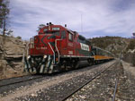
Casa y Museo de Artesanias de Creel

Casa y Museo de Artesanias de Creel
Located in front of Creel’s main plaza, on Tarahumara Street. This museum has an important collection of Tarahumara art and crafts, allowing you to learn about their customs and cosmovision. There is also a showroom with an exhibit of prize-winning Raramuri crafts. Open Monday through Saturday from 9:00 to 6:00 and Sunday from 9:00 to 1:00.

The Chihuahua al Pacífico Railroad

The Chihuahua al Pacífico Railroad - El Chepe
The Chp (Chihuahua al Pacifico, or El Chepe) was privatized in 1998 being taken over by the private rail franchise Ferromex. The CHP is a major rail line in northwest Mexico, linking the city of Chihuahua, Chihuahua, to the town of Los Mochis, Sinaloa, near the Pacific coast. It runs 650 km (400 miles), traversing the Copper Canyon, a beautiful and rugged series of canyons that have led some to call this the most scenic railroad trip on the continent.

Conjunto Mogollon - Serpiente Caves

Conjunto Mogollon - Serpiente Caves
Located in the northern part of the Parque Natural Barrancas del Cobre, 46 km (29 mi) west of Ciudad Madera, near the bottom of Huapoca Canyon. At this site you’ll see the Cueva del Nido and Serpiente caves. This cave is actually a very large overhang open on both sides. There are 14 adobe rooms and a hallway that went from one side of the overhang to the other, "snaking" through past the rooms.

Copper Canyon Area Cities

Copper Canyon Area Cities
Copper Canyon (Barranca del Cobre) is a region in Northwest Mexico providing some of the most spectacular scenery in all of Mexico. The CHP is a major rail line in northwest Mexico, linking the city of Chihuahua, Chihuahua, to the town of Los Mochis, Sinaloa, near the Pacific coast. Along the tour the trains stops in several cities all with unique attractions. Explore the cities of Los Mochis, Creel, El Fuerte and many others...

Cuarenta Casas

Cuarenta Casas
Located north of Parque Natural Barrancas del Cobre, 50 km (31 mi) northwest of Ciudad Madera in the Huapoca Canyon. The Cuarenta Casas (Forty Houses) archaeolgical site is the most well known and accessible of the cave and cliff dwellings in northern Mexico. This is a group of 15 adobe structures that were built in the 13th century. This is the region’s second most important archaeological zone after Paquime. It is not certain if there were actually forty houses as fewer remain today.

Cusarare Falls

Cusarare Falls
Located 14 miles (22 kms.) south of Creel along the Creel to Guachochi road, is Cusarare Falls. 'Cusarare' meaning 'Place of the Eagles' to the Raramuri, is an apt name for this small, side canyon that abuts the much larger canyon system, Cusarare Falls is one of the most popular destinations for visitors to the Sierra Tarahumara. Cusarare Falls drops 100 feet (30 meters) to join the Urique River in the Copper Canyon. This area is surrounded by a pine forest. Nearby is Recowata hot springs.

Escultura de Cristo Rey

Escultura de Cristo Rey
Located on the corner of Av. Gran Vision and Cristo Rey, in the town of Creel. This white stone statue, which stands on top of a hill, is 8 meters (26 feet) tall. To reach the statue you’ll have to ascend the 500-meter (1,650-foot) hillside and a stairway. From the top of the hill it offers panoramic views the city. This is an excellent place to take photographs of the city of Creel and the Copper Canyon.

Huapoca Suspension Bridge

Huapoca Suspension Bridge
Located in the Huapoca Canyon is the Puente Huapoca Suspension Bridge, built in 1950. The suspension bridge over the Huapoca River is the main road used by loggers to transport their log-laden trucks to Madera, Chihuahua, Mexico. Adventurous travelers will find this an exciting extension to a trip to the archaeolgical sites of Cuarenta Casas and Casas Grandes. Local tourist guides lead raft and kayak trips through this narrow, scenic passage. Less than a mile upriver

Lake Arareko

Lake Arareko
Set at 8000' (2400m), Lake Arareko is a beautiful alpine lake nestled amongst historical Missions, gigantic rock formations and Raramuri cave dwellings still in use. Lake Arareko is located in the central part of the Parque Natural Barrancas del Cobre, on the commons of San Ignacio de Arareko, 264 km (163 mi) from Creel. This 40-hectare (99-acre) lake area lies in a forest with pines, oaks and madrones. It is common to see Tarahumari people cleaning and bathing here.

Mision Jesuita Santo Cinco Señores de Cusarare

Mision Jesuita Santo Cinco Señores de Cusarare
Located in the central zone of the Parque Natural Barrancas del Cobre, 22 km (14 mi) from Creel, off the Guachochi Highway. This is one of the region’s oldest missions and an important site where many Tarahumara celebrations take place. The original architecture of the church has been kept intact and the interior is adorned with Raramuri paintings. Often referred as San Ignacio Mission or Cusarare Mission.

Museo Loyola in Cusarare - Loyola Museum

Museo Loyola in Cusarare - Loyola Museum
Just 13 miles (22 km) from outside of Creel you'll find the Village of Cusarare. There is an ancient mission here built in 1741, the Loyola Museum exhibiting the 'lost' paintings of many famous Mexican artists. . This museum has a collection of more than 45 sacred works of art from the 16th to 18th centuries. Nearby you'll also find in the area the well known waterfall 'Cusarare' which you'll get to by following a winding path through the forest. Located 25 km (16 mi) southeast of Creel.

Paquime

Paquime
Located northwest of the Copper Canyon, 350 km (217 mi) from the city of Chihuahua and a half-kilometer from Casas Grandes. This was the region’s main pre-Hispanic settlement and one of the oldest commercial and religious centers in the north. The adobe buildings have T-shaped doors and a maze-like distribution. You’ll also see an irrigation system that brought water into the city. The site has a museum, Museo de las Culturas del Norte. Open daily from 8:00 to 5:00.

Peña del Gigante - Balancing Rock

Peña del Gigante - Balancing Rock
It is the highest vertical rock face in the country, dropping a straight which has the highest vertical wall of Mexico at 885 meters (2,290 feet). to the Candameña River at its base. one of the tallest vertical rock faces in the country. The five routes have 5.12 and 5.13 grades of difficulty, making them ideal for rappelling and climbing. Located in the northwestern part of the Parque Natural Barrancas del Cobre, in the Candameña Canyon, within the Parque Nacional Cascada de Basaseachi.

Piedra Volada

Piedra Volada
Cascada Piedra Volada or in English "Flying Stone" is about a day's hike from Basaseachi Falls and can only be reached on foot. Pierda Volada is the 11th largest waterfall in the world, and at the height of 1,486 feet (453 meters) it is the tallest waterfall in Mexico , however since it does not have water year around, it really can't technically be classified as the tallest waterfall. The lookout offers a view of the 700-meter (2,310-foot) cliff and a pine and oak forest.

Recowata Hot Springs

Recowata Hot Springs
Just 13 miles (22 km) from Creel you can hike up to Cusarare falls then continuing to Recowata hot springs. This very popular hot springs sits at the bottom of a small canyon called Tararecua and can be reached by car, bicycle, horseback or even on foot. The spring itself is a scalding 145°F (127°C); but it drains into the river and cools, providing a soothing transitional area of warm water. There are also ancient cave paintings on the path to the falls that you don't want to miss.

San Miguel de Satevó Mision

San Miguel de Satevó Mision
The Jesuit mission of San Miguel de Satevó, just outside the town of Creel in Copper Canyon Mexico, is known as the "Lost Mission" as there are no records describing it's existence. Believed to have been constructed in the 1760's, the mission is one of the canyon's best preserved Missions. It's setting is ideal near the edge of the Batopilas River.

Tarahumara Indians - Rarámuri

Tarahumara Indians - Rarámuri
The Tarahumara people (known as Rarámuri in their own language) of northern Mexico’s Sierra Madre are among the largest and most traditional native American societies in all of North America. There doesn’t appear to be a consensus regarding the number of Tarahumara Indians living in the Sierra Madre (also known as the Sierra Tarahumara) but estimates range from 35,000 to 70,000.

Valley of the Frogs

Valley of the Frogs
Located in the town of Creel is the Valley of the Frogs (Valle de Ranas), named for the group of colossal shaped rocks that resemble frogs. The rock formations where sculpted by erosion of the volcanic and sedimentary rock layers, producing some interesting rocks formations. Nearby visit Valley of the Mushrooms and the Valley of the Monks.

Valley of the Monks

Valley of the Monks
Located in the town of Creel is the Valley of the Monks (Valle de Monjes), named for the group of colossal vertical shaped rocks there. The rock formations where sculpted by erosion of the volcanic and sedimentary rock layers, producing some interesting rocks formations. It was originally called Valley of the Erect Penises, however it was changed to the valley of the monks as too many American tourists were offended by the litteral translation. Nearby visit Valley of the Mushrooms.

Valley of the Mushrooms

Valley of the Mushrooms
Located in the town of Creel is the Valley of the Mushrooms (Valle de Ongos), named for the group of colossal mushroom shaped rocks there. The rock formations where sculpted by erosion of the volcanic and sedimentary rock layers, producing some interesting balanced rocks. Similar to some of Salvador Dali's paintings. Nearby visit less famous neighbors the Valley of Breasts (Valle de Chichis) and Frog Valley (Valle de Ranas).

Back To Top

Mexico Insurance Free Quote

To start your Mexican Insurance QUOTE select one

Already purchased a Mexican Auto Insurance Policy?